Land Surveying

Batterman has offered Professional Land Surveying services for Wisconsin and Illinois since 1917. Our professional staff serves both commercial and residential sectors out of our offices in Beloit, Elkhorn, and Janesville.

Through the years, we have kept pace with the changes in technology that have transformed the way survey work is performed, while maintaining the application of solid fundamentals and sound principles that are at the heart of professional surveying. Our trained staff ensures that our clients receive high-quality and cost-effective services on time and within established budgets.

Give us a call at 608-365-4464 or fill out the form to request a quote! Surveying services are not currently being offered in Illinois.

A Plat of Survey is also referred to as a property survey, lot line survey, or boundary survey.

The purpose of this type of survey is to retrace existing property descriptions. It can be for either commercial or residential properties and is often the first step in any type of proposed development or improvement, or possibly the sale of the parcel. Generally, the property corners are established by a combination of thorough research and fieldwork by a survey crew. Corners are either recovered or replaced, if missing, based on careful computation and evaluation of evidence collected.   

For example, if you are considering installing a fence on your property, a Plat of Survey is important to ensure that you know where your property corners are so that your fence can be installed appropriately. In addition to establishing the property corners, other improvements can be measured and added to the mapping at the client’s request, such as buildings or other site improvements, which are sometimes required by local authorities to sell the property. 

The American Land Title Association (ALTA) and the National Society of Professional Surveyors (NSPS) derived a set of minimum standards to follow when preparing ALTA/NSPS Land Title Surveys. This type of survey is the most comprehensive and is used predominantly for commercial real estate properties and transactions, such as shopping centers, retail stores, office buildings and complexes, industrial buildings, and apartment complexes. 

Our experienced team of Professional Land Surveyors and Technicians are available to provide ALTA/NSPS Land Title Surveys that are essential to the unique needs of title insurance matters. The ALTA/NSPS Land Title Survey process, including performing the required research, on-site fieldwork, mapping, and certification can be expertly handled by Batterman. Batterman takes pride in effectively communicating throughout the duration of the survey process to ensure that we conduct surveys and mappings that are of professional quality and appropriately uniform, complete, accurate, and done in a timely manner. 

Elevation Certificates are a standard Federal Emergency Management Agency (FEMA) form that is used to aid in determining the relationship of a structure or parcel of land to the established base flood elevation. If the surveyed data reveals that the structure or parcel of land is above the base flood elevation, then the client may wish to proceed with a Letter of Map Amendments (LOMA), which is a formal request to FEMA to remove the structure or part of the parcel of land from Special Flood Hazard Area (SFHA), commonly known as the floodplain.  An Elevation Certificate is commonly requested by mortgage lenders when a property is being mortgaged. 

Elevation Certificates must be prepared by a Licensed Land Surveyor, Registered Professional Engineer, or architect who is authorized by Commonwealth, State, or local law to certify elevation information. 

An Elevation Certificate or LOMA provide information on the existing site conditions of your property which will assist the insurance companies in establishing your insurance premiums based on the risk and impact of possible flooding.  

A topographic survey is used to determine the elevations of the existing ground, including the location of natural and/or manmade features that are not always visible on traditional maps or surveys. Topographic maps are commonly used by landowners, engineers, architects, planners, developers, landscape architects, and governmental agencies for numerous uses, ranging from land use or development, site design or re-design, and flood studies. Batterman takes care in setting accurate site benchmarks and gathering pertinent details knowing this data is used for intricate design and future construction. Give us a call to chat about your project! 

A land division is the process of creating and defining new lots. A Subdivision Plat is the necessary instrument used to create five or more lots, and a Certified Survey Map is the instrument that is used to create four or fewer lots. The Certified Survey Map is commonly used to separate farm buildings from the remaining lands. Both Certified Survey Maps and Subdivision maps require a combination of State, County, Town, and City/Village review and approval. Batterman coordinates and facilitates the applications to the governing authority, any zoning changes, and attendance at public meetings that are required as part of the land division process.  

An easement gives specific rights or interests in land for lawful use of or over the estate of the owner for use by another. For example, a common type of easement is a utility easement, which gives utility companies specific rights which can include access to your property for utility placement and maintenance. Understanding easements and their purpose is why it is so important to be aware of easements on your property before moving forward with any improvements or construction plans. Batterman can assist landowners in mapping and offering guidance on easement questions. Additionally, we can prepare comprehensive new easement exhibits and legal descriptions for use in legal documents. 

Batterman offers 3D scanning, an advanced surveying technology to effectively capture high-resolution site imagery quickly and with unparalleled precision. Our technology-focused staff uses Trimble SX-10 equipment and Trimble Business Center software to provide our clients with precise and dense point cloud information.

3D scanning is often beneficial for: 

  • Detailed vertical topographic surveys (building facades, overhead piping, or obstructions) 
  • Capturing picture-like quality point cloud viewing for sharing with anyone (architecture firms, design engineers, etc.) 
  • Quickly capturing current or as-built field data 
  • Classified point-cloud data exports for use in various post-processing software 

Batterman offers UAV (drone) mapping services. Our licensed UAV pilots have the necessary knowledge, equipment, software, and training to provide flights for gathering data that can be used for multiple aspects of project development. Drone mapping can be used to enhance surveying and engineering services or as a standalone product. By gathering high-resolution aerial imagery that is post-processed to generate topographic relief that can be used for: 

    • Cost-effective mapping for initial site planning 
    • Comprehensive presentation maps based upon current site conditions 
    • Quarry operation documenting aggregate quantity calculations 
    • Construction site monitoring and progress 
    • Photographs and videos for use in marketing materials 

    Need a quote for a land survey?

    Name(Required)
    Project Street Address(Required)
    This field is for validation purposes and should be left unchanged.

    Featured Projects

    I-39 Highway Project

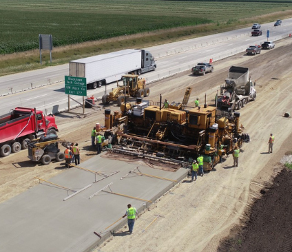
    I-39 Reconstruction (STH 11 to USH 14)

    This complex IH 39 expansion project involved reconstruction of the most urban section of the IH 39 corridor from STH 11 to USH 14. Key components of this complex staged project include twelve bridges, six MSE retaining walls, nine noise walls, major grading operations, four lanes of concrete pavement, and all new storm sewer.
    County H In Kenosha County

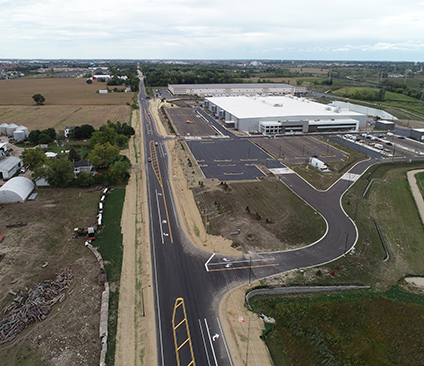
    County Highway H Reconstruction

    This 0.8-mile reconstruction/perpetuation project includes geometric expansion and turn lane additions required for a 350,000 SF Kroger Distribution Center.
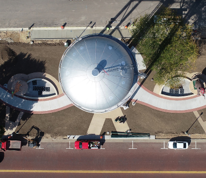
    Delavan Tower Project

    Delavan Tower Park

    Project Description: Located in the heart of downtown Delevan, the site was constrained on all sides by a State Highway, residential houses, and downtown businesses. The City wanted to expand the park’s square footage to help establish the park as a central, community-defining, public, and event space.
    Beloit Powerhouse Bridge Walk

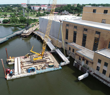
    Beloit College Powerhouse Riverwalk

    10 span pedestrian bridge along the Rock River as part of the Beloit College Powerhouse Building.  The project will be a part of the riverfront revitalization commitment made by the City of Beloit and will connect a gap in the riverfront trail system through the area.